Antipode of America: What Part of the World is Opposite the USA?
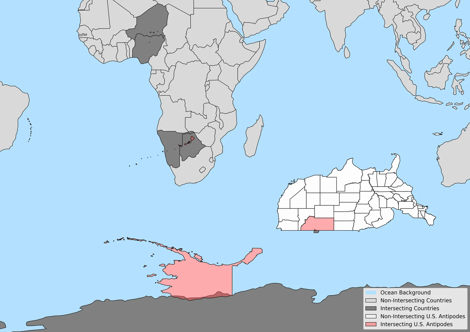
Answer: Most U.S. antipodal points lie in the Indian Ocean. Only Alaska and Hawaii have small land overlaps, in Antarctica, Africa (Niger, Botswana, Namibia), and the French Southern Territories.
Which U.S. State Antipodes Align with Other Landmasses on the Earth?
This table presents U.S. states and territories whose antipodal points overlap with landmasses in other countries. Overlapping areas are measured in square kilometers.
| State/Territory | Country | Overlap Area (km²) |
|---|---|---|
| Alaska | Antarctica | 66,998.7 |
| American Samoa | Niger | 1,353.4 |
| American Samoa | Nigeria | 151.6 |
| Hawaii | Botswana | 25,107.8 |
| Hawaii | Namibia | 893.2 |
| Montana | French Southern and Antarctic Lands | 1,435.6 |
All U.S. State and Territory Antipodes
Explore the antipodal coordinates for every U.S. state and territory. Click on any state name to view its detailed antipode page with an interactive map.
| State/Territory | Centroid Latitude | Centroid Longitude | Antipode Latitude | Antipode Longitude |
|---|---|---|---|---|
| Alabama | 32.7823° | -86.8434° | -32.7823° | 93.1566° |
| Alaska | 64.6540° | -152.9254° | -64.6540° | 27.0746° |
| American Samoa | -13.9716° | -170.0782° | 13.9716° | 9.9218° |
| Arizona | 34.3359° | -111.6664° | -34.3359° | 68.3336° |
| Arkansas | 34.9174° | -92.4365° | -34.9174° | 87.5635° |
| California | 37.3502° | -119.7329° | -37.3502° | 60.2671° |
| Colorado | 39.0269° | -105.5479° | -39.0269° | 74.4521° |
| Commonwealth of the Northern Mariana Islands | 16.8487° | 145.5950° | -16.8487° | -34.4050° |
| Connecticut | 41.5769° | -72.7377° | -41.5769° | 107.2623° |
| Delaware | 38.9979° | -75.4530° | -38.9979° | 104.5470° |
| District of Columbia | 38.9048° | -77.0163° | -38.9048° | 102.9837° |
| Florida | 28.4683° | -82.5657° | -28.4683° | 97.4343° |
| Georgia | 32.6628° | -83.4327° | -32.6628° | 96.5673° |
| Guam | 13.4429° | 144.7695° | -13.4429° | -35.2305° |
| Hawaii | 21.0411° | -158.1855° | -21.0411° | 21.8145° |
| Idaho | 44.4675° | -114.6839° | -44.4675° | 65.3161° |
| Illinois | 40.1662° | -89.1478° | -40.1662° | 90.8522° |
| Indiana | 39.9452° | -86.2792° | -39.9452° | 93.7208° |
| Iowa | 42.0905° | -93.5022° | -42.0905° | 86.4978° |
| Kansas | 38.5002° | -98.3810° | -38.5002° | 81.6190° |
| Kentucky | 37.5337° | -85.2849° | -37.5337° | 94.7151° |
| Louisiana | 30.9290° | -91.8223° | -30.9290° | 88.1777° |
| Maine | 45.3008° | -69.1973° | -45.3008° | 110.8027° |
| Maryland | 38.9526° | -76.6913° | -38.9526° | 103.3087° |
| Massachusetts | 42.1637° | -71.5072° | -42.1637° | 108.4928° |
| Michigan | 44.9545° | -85.7652° | -44.9545° | 94.2348° |
| Minnesota | 46.4167° | -94.1981° | -46.4167° | 85.8019° |
| Mississippi | 32.7405° | -89.6523° | -32.7405° | 90.3477° |
| Missouri | 38.3981° | -92.4872° | -38.3981° | 87.5128° |
| Montana | 47.0728° | -109.6512° | -47.0728° | 70.3488° |
| Nebraska | 41.5433° | -99.8188° | -41.5433° | 80.1812° |
| Nevada | 39.4138° | -116.6668° | -39.4138° | 63.3332° |
| New Hampshire | 43.6910° | -71.5699° | -43.6910° | 108.4301° |
| New Jersey | 40.1188° | -74.6547° | -40.1188° | 105.3453° |
| New Mexico | 34.4614° | -106.1064° | -34.4614° | 73.8936° |
| New York | 42.9450° | -75.5970° | -42.9450° | 104.4030° |
| North Carolina | 35.5327° | -79.1316° | -35.5327° | 100.8684° |
| North Dakota | 47.4686° | -100.4711° | -47.4686° | 79.5289° |
| Ohio | 40.4335° | -82.7056° | -40.4335° | 97.2944° |
| Oklahoma | 35.5991° | -97.5155° | -35.5991° | 82.4845° |
| Oregon | 43.9732° | -120.6024° | -43.9732° | 59.3976° |
| Pennsylvania | 40.9071° | -77.8399° | -40.9071° | 102.1601° |
| Puerto Rico | 18.2160° | -66.4146° | -18.2160° | 113.5854° |
| Rhode Island | 41.5958° | -71.5247° | -41.5958° | 108.4753° |
| South Carolina | 33.8872° | -80.8678° | -33.8872° | 99.1322° |
| South Dakota | 44.4553° | -100.2322° | -44.4553° | 79.7678° |
| Tennessee | 35.8471° | -86.3385° | -35.8471° | 93.6615° |
| Texas | 31.5257° | -99.3326° | -31.5257° | 80.6674° |
| United States Virgin Islands | 18.0606° | -64.8392° | -18.0606° | 115.1608° |
| Utah | 39.3642° | -111.6824° | -39.3642° | 68.3176° |
| Vermont | 44.0854° | -72.6609° | -44.0854° | 107.3391° |
| Virginia | 37.5203° | -78.6617° | -37.5203° | 101.3383° |
| Washington | 47.4342° | -120.5914° | -47.4342° | 59.4086° |
| West Virginia | 38.6519° | -80.6087° | -38.6519° | 99.3913° |
| Wisconsin | 44.6749° | -89.7447° | -44.6749° | 90.2553° |
| Wyoming | 43.0321° | -107.5514° | -43.0321° | 72.4486° |
Most of the U.S. Antipodal Points are in the Ocean — This is Where They Land
Most of the antipodal points for the contiguous United States and Alaska fall within the vast expanses of the Indian and Southern Oceans. This is largely due to the overwhelming presence of oceanic areas in the Southern Hemisphere—over 80% of the landmasses in the Northern Hemisphere lack direct land-based antipodes. Instead, when a point from the United States is projected through the Earth's center, it most often emerges in open waters far from any continental landmass.
The Indian Ocean, which spans over 70 million square kilometers, is home to a significant portion of U.S. antipodes, particularly those from the western states. The Southern Ocean, which encircles Antarctica, also captures a large number of antipodal points, especially for northern U.S. states like Montana and North Dakota. This ocean, defined officially in 2000, is unique in that its currents create a distinct, fast-moving Antarctic Circumpolar Current, which helps regulate global temperatures. While Hawaii and certain Pacific territories do have some land-based antipodes, most of the U.S. shares an opposite side of the world with the deep, remote oceanic expanses, reinforcing the idea that much of our planet's surface is covered in water rather than land.
What is an Antipode?
An antipode refers to a point on the Earth's surface that is diametrically opposite to another point. Simply put, if you were to draw a straight line from one point on the Earth's surface, through the center of the Earth, to the other side, you would reach the antipode of the original point.
How is an Antipode Calculated?
To calculate the antipode of a given location, a few simple steps are involved:
- For the latitude, simply invert the sign. For example, the antipode of 45° N will be 45° S.
- For the longitude, subtract the longitude from 180° and invert the direction (E becomes W or W becomes E). For example, the antipode of 75° W will be 105° E.
The antipodal point is theoretically precise; however, since the Earth is not a perfect sphere but rather an oblate spheroid, real-world calculations involve geospatial techniques that take into account variations in terrain and the Earth's ellipsoid shape. Additionally, antipodal points are mostly located in the oceans, as water covers more than 70% of the Earth's surface.
Frequently Asked Questions
- What part of the world is opposite the United States?
- Most points lie in the Indian Ocean; only Alaska and Hawaii antipodally align with land.
- Which U.S. states overlap land antipodes?
- Alaska (Antarctica), American Samoa (Niger, Nigeria), Hawaii (Botswana, Namibia), Montana (French Southern Territories).