Antipode of Montana
The antipode of Montana is the point on Earth diametrically opposite its centroid. The state's centroid is at 47.0728°, -109.6512°, and its antipodal point is at coordinates -47.0728°, 70.3488°.
About the Antipode of Montana
An antipode is the point on Earth's surface that is diametrically opposite to a given location. For Montana, with a centroid at coordinates 47.0728°, -109.6512°, the antipodal point is at -47.0728°, 70.3488°.
How is the Antipode Calculated?
To find the antipode of any location:
- Latitude: Invert the sign (47.0728° becomes -47.0728°)
- Longitude: Add or subtract 180° (-109.6512° becomes 70.3488°)
Why Are Most U.S. Antipodes in the Ocean?
Over 70% of the Earth's surface is water, and the contiguous United States lies entirely in the Northern Hemisphere. The antipodal points for most U.S. states fall in the Southern Hemisphere's vast Indian Ocean. Only Alaska and Hawaii have small land overlaps with Antarctica, Africa, and French Southern territories.
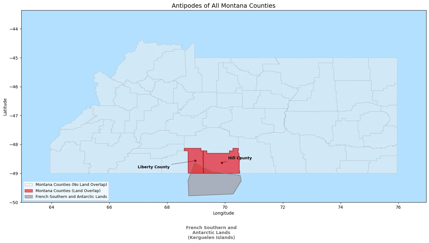
Montana's Terrestrial Antipodes
While most of Montana's antipode falls in the open Indian Ocean, two northern counties have land antipodes. Liberty County and Hill County, located along Montana's border with Canada, are antipodal to the Kerguelen Islands, part of the French Southern and Antarctic Lands.
This makes Montana one of the few contiguous U.S. states with any terrestrial antipode—if you could drill straight through the Earth from these northern Montana counties, you would emerge on the remote, windswept Kerguelen Islands in the southern Indian Ocean.
Montana Counties with Land Antipodes
The following table shows the Montana counties whose antipodes overlap with land:
| County | Antipodal Territory | Overlap Area (km²) |
|---|---|---|
| Liberty County | French Southern and Antarctic Lands (Kerguelen Islands) | 955.76 |
| Hill County | French Southern and Antarctic Lands (Kerguelen Islands) | 479.18 |
Combined, these two counties have approximately 1,435 km² of antipodal land overlap with the Kerguelen Islands. The remaining 54 Montana counties are entirely antipodal to ocean.
About the Kerguelen Islands
The Kerguelen Islands are a remote archipelago in the southern Indian Ocean, about 3,300 km from the nearest populated land. Part of the French Southern and Antarctic Lands, the islands are known for their harsh, windy climate and are home to a small population of scientists and researchers at the Port-aux-Français research station.
Explore More Antipodes
Curious about other states? Check out our complete list of U.S. state and territory antipodes. Or use the Antipode Finder to search any location on Earth.
Data Sources
Montana county boundary data used for antipode calculations:
- Montana County Boundaries, Montana State Library Geographic Information